Features
Industries
Who we serve
Resources
Sign in
Get Started - $500/month
No commitment. No implementation fee. Unlimited users. Cancel anytime
.webp)
When a storm is approaching, you’ll often see terms like Storm Watch and Storm Warning in weather alerts
Most people assume they mean the same thing. But they don’t!
And in severe weather, misunderstanding those words can mean the difference between “we’re ready” and “we’re caught off guard.”
Let’s break it down and understand!
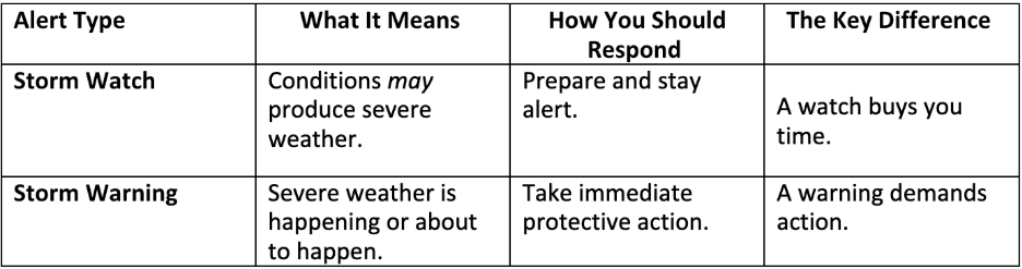
A storm watch is a heads-up. A signal that the atmosphere is brewing something potentially dangerous. Something could happen. Not guaranteed, but very possible. The National Weather Service describes it as a period when conditions are favorable for severe weather (thunderstorms, tornadoes, hail, or winter storms).
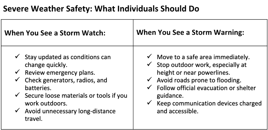
A storm watch gives you time to:
Storm watches typically cover larger geographic regions because forecasters are monitoring broad patterns, not pinpointing exact impact zones yet.
A storm warning, on the other hand, means the threat is no longer theoretical. It’s happening or is about to happen.
The NWS issues a warning when a storm is confirmed by radar, spotted by trained observers, or supported by highly reliable models.
Warnings are issued for smaller, more specific locations where the danger zone is defined, and responders have high confidence it’ll be hit.
%20(1).webp)
Timing saves lives. A watch might be issued hours or even a full day before conditions turn dangerous, giving people and storm response teams time to prepare. For example, a typical severe-storm or tornado watch may come 1–4 hours ahead of the first signs of trouble, while a warning may arrive 10–20 minutes before impact.
If you work with/in utilities, construction, vegetation management, or transportation, the watch-to-warning timeline influences:
Research shows that half the people in mid-south of the US still struggle to distinguish between a watch and a warning. This can lead to delayed or inappropriate responses during severe weather. Confusion at this time can slow decision-making during severe weather. Clear understanding keeps people calm, focused, and ready to respond appropriately when conditions shift from “possible” to “imminent.”
For utilities, storms are operational challenges.
As storms intensify, utilities need more than alerts. They need clarity, coordination, and real-time visibility. That’s exactly where KYRO AI helps.
KYRO enables utilities to:
When a watch shifts to a warning, utilities don’t have time to scramble. KYRO AI gives you the structure, speed, and situational awareness you need to respond confidently and safely.
A storm watch means prepare. A storm warning means act immediately.
Understanding both helps protect homes, workers, infrastructure, and communities. And with platforms like KYRO AI supporting planning, communication, and field coordination, utilities can navigate severe weather with far greater control and fewer delays.
Be storm-ready before the warning hits. Would you like to see how KYRO AI helps utilities build validated rosters, accelerate restoration, and protect crews? Get a quick walkthrough today!
When a storm is approaching, you’ll often see terms like Storm Watch and Storm Warning in weather alerts
Most people assume they mean the same thing. But they don’t!
And in severe weather, misunderstanding those words can mean the difference between “we’re ready” and “we’re caught off guard.”
Let’s break it down and understand!
A storm watch is a heads-up. A signal that the atmosphere is brewing something potentially dangerous. Something could happen. Not guaranteed, but very possible. The National Weather Service describes it as a period when conditions are favorable for severe weather (thunderstorms, tornadoes, hail, or winter storms).
A storm watch gives you time to:
Storm watches typically cover larger geographic regions because forecasters are monitoring broad patterns, not pinpointing exact impact zones yet.
A storm warning, on the other hand, means the threat is no longer theoretical. It’s happening or is about to happen.
The NWS issues a warning when a storm is confirmed by radar, spotted by trained observers, or supported by highly reliable models.
Warnings are issued for smaller, more specific locations where the danger zone is defined, and responders have high confidence it’ll be hit.
Timing saves lives. A watch might be issued hours or even a full day before conditions turn dangerous, giving people and storm response teams time to prepare. For example, a typical severe-storm or tornado watch may come 1–4 hours ahead of the first signs of trouble, while a warning may arrive 10–20 minutes before impact.
If you work with/in utilities, construction, vegetation management, or transportation, the watch-to-warning timeline influences:
Research shows that half the people in mid-south of the US still struggle to distinguish between a watch and a warning. This can lead to delayed or inappropriate responses during severe weather. Confusion at this time can slow decision-making during severe weather. Clear understanding keeps people calm, focused, and ready to respond appropriately when conditions shift from “possible” to “imminent.”
For utilities, storms are operational challenges.
As storms intensify, utilities need more than alerts. They need clarity, coordination, and real-time visibility. That’s exactly where KYRO AI helps.
KYRO enables utilities to:
When a watch shifts to a warning, utilities don’t have time to scramble. KYRO AI gives you the structure, speed, and situational awareness you need to respond confidently and safely.
A storm watch means prepare. A storm warning means act immediately.
Understanding both helps protect homes, workers, infrastructure, and communities. And with platforms like KYRO AI supporting planning, communication, and field coordination, utilities can navigate severe weather with far greater control and fewer delays.
Be storm-ready before the warning hits. Would you like to see how KYRO AI helps utilities build validated rosters, accelerate restoration, and protect crews? Get a quick walkthrough today!

Rabiya Farheen is a content strategist and a writer who loves turning complex ideas into clear, meaningful stories, especially in the world of utility, tech, AI, and B2B SaaS. She works closely with growing teams to create content that doesn’t just check SEO boxes, but actually helps people understand what a product does and why it matters. With a knack for research and a curiosity that never quits, Rabiya dives deep into industry trends, customer pain points, and data to craft content that feels super helpful and informative. When she’s not writing, she’s probably reading, painting, and exploring her creative side— or you'll find her hustling around for social causes, especially those that empower girls and women.
.jpg)
.jpg)
.jpg)